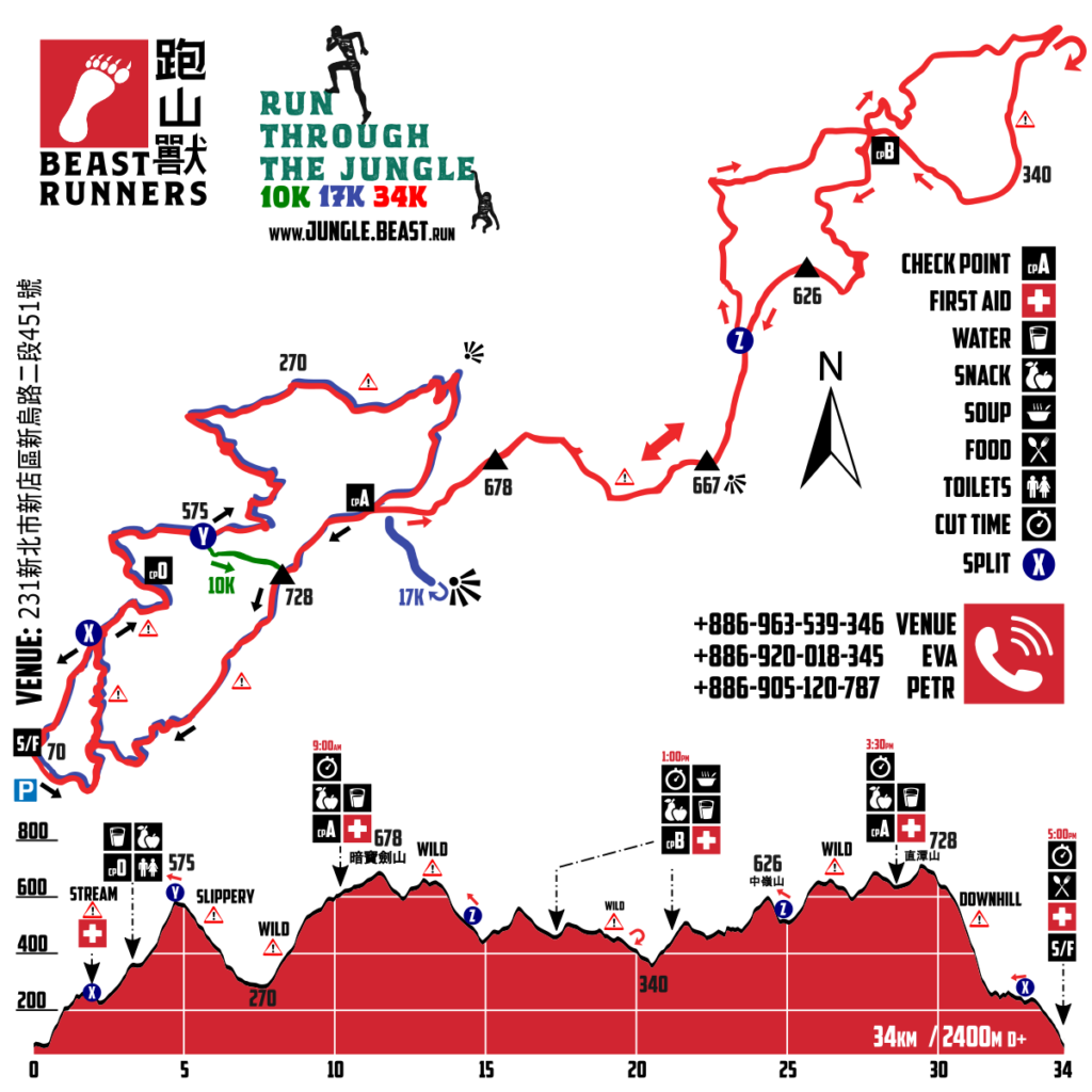
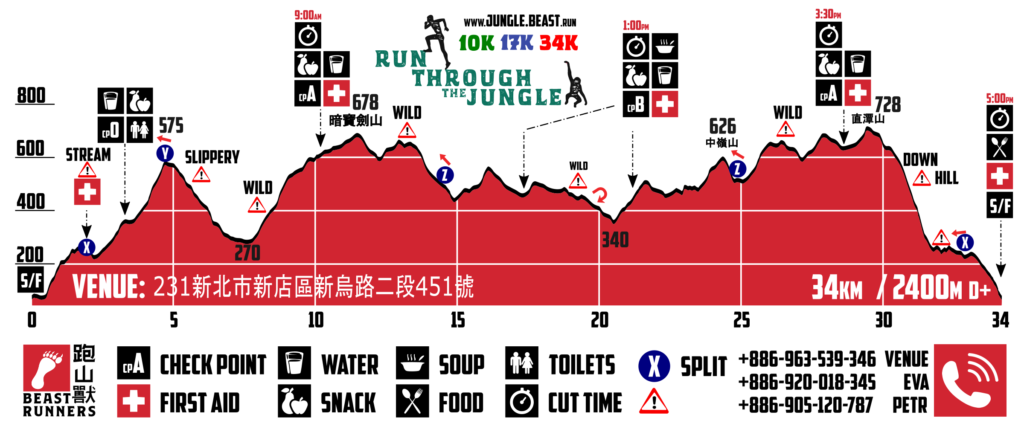
Course 賽程
- 10km / 800m D+
- start 8am, cut time 5 hours
- MOWGLI run – Easier, great trail experience
- 17km / 1250m D+
- start 7am, cut time 7 hours
- 1 new ITRA point
- TARZAN trail – Some difficulties
- 34km / 2400m D+
- start 6am, cut time 11 hours
- 2 new ITRA points
- RAMBO veteran adventure – Very difficult
- 10公里/總爬升800公尺
- start 8am, 關門時間5小時
- 森林王子毛克力 – 較簡單,很棒的初階山徑越野體驗
- 17公里/總爬升1250公尺
- start 7am, 關門時間7小時
- ITRA1點
- 森林之王泰山 – 有些困難度會爬越超過兩個叢林
- 34公里/總爬升2400公尺
- start 6am, 關門時間11小時
- ITRA2點, 藍波 – 非常困難
Difficulty: Course of Run Through The Jungle is designed in very wild nature of Taipei surrounding. There are many sections in jungle and deep forest. The longest course required experience on wild trails and full mandatory equipment for semi-autonomy in nature. Middle distance is great for adventure trail runners who wish try adventure in wild nature. Short option is easier but not easy. Please understand difficulty of the event before sign up for it.
困難度: 叢林野跑,賽道在大台北區野生自然的環境裡,這裡有許多段在叢林及森林的深處,最長距離賽程需要對原始野外山徑非常有經驗的選手,必須完全攜帶強制性裝備,採半自助式模式。中距離賽程是適合喜歡探險的越野選手,喜歡在野生大自然裡冒險及探索的朋友們。最短距離賽事適合初階,容易,喜歡徜徉在優美山徑的選手
- SAFETY FIRST – trails are very narrow and slippery – please pass others gently and inform them before
- RESPECT MANDATORY EQUIPMENT and RULES (read here)
Cut time 11 hours for 34km:
- cpA1 09:00am – Have to reach cp A (10km) within 3:00 hours after start. Who will be later will be changed to 17km category (no DNF, but can finish 17km)!
- cpB2 1:00pm (DNF)
- cpA2 3:30pm (DNF)
| TIME ESTIMATION | cp0 | cpA1 | cpB1 | cpB2 | cpA2 | FINISH |
|---|---|---|---|---|---|---|
| 11 hours finish estimation (朱瑞玹 Jui Hsuan Chu 2017) | 1:07:00 | 2:47:00 | 4:45:00 | 6:37:00 | 9:12:00 | 10:58:54 |
| 9 hours finish estimation (許智皓 Chih-Hao Hsu 2017) | 1:03:00 | 2:19:00 | 3:55:00 | 5:22:00 | 7:26:00 | 8:59:49 |
| 7 hours finish estimation (Dawid Janczak 2017) | 0:44:00 | 1:51:00 | 3:10:00 | 4:16:00 | 5:53:00 | 6:57:12 |
| 4:56:08 course record (周青 Ching Chou 2017) | 0:35:00 | 1:29:30 | 2:28:30 | 3:16:30 | 4:18:30 | 4:56:08 |
notice: The time estimation was took from ideal condition on course in 2017 and very depends on certain runner. During the rain the course will be more muddy and most of the runners will significantly slow down in second half!
GPX and MAP
- GPX and MAP: https://tinyurl.com/RTTJGPXMAP
- DOWNLOAD .GPX file to GPS device is mandatory for 34km participants!
Course on GOOGLE map
- in most parts the course leads clockwise!
- open map in full window: https://drive.google.com/open?id=1EcqiOaK9RCqPUdGuKulx1oPIUgg
Course Marking
All courses are marked with red/reflective and ORANGE satin ribbon. Runner has to pay attention for marking and be present on course, in case feel lost return back in same way to last ribbon and figure out. Change of direction or turns will be marked at least with one ribbon. In trail without turns will be ribbons at least every 200 m, 2-3 minutes. Signs of direction will be used rarely; there will not be marshals on course.
Short cuts are not permitted. Every runner must stay on the way-marked paths. Any runner who voluntarily leaves the way-marked path is no longer under the responsibility of the organization.
Map of RTTJ


